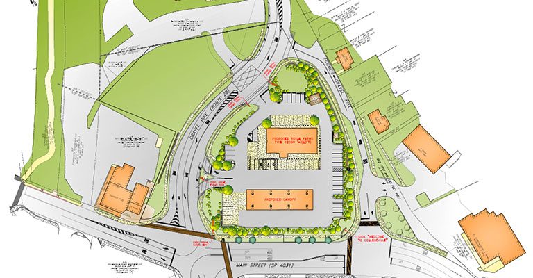
Final Land Development Plan: Royal Farms
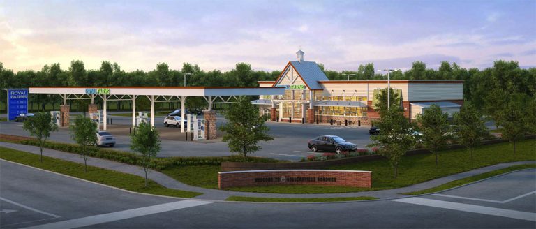
At its September 19, 2019 meeting, the Collegeville Borough Planning Commission granted final approval to the Royal Farms land development to be built in the field at Main Street and Rt 29 (Map it). In addition to building a Royal Farms convenience store with a gas island, the developer will reroute Second Avenue at Main Street to link directly with First Avenue (aka Gravel Pike) at the Powerhouse. This direct link will eliminate the current dogleg configuration.
Royal Farms had received a zoning variance on July 18, 2017 to build a gas station on the lot, a portion of which is located in the Perkiomen Creek floodplain. The zoning was not changed but Council approved some amendments to the Commercial Office (CO) District to allow a convenience store with gas pumps. In February 2017, however, PennDOT let them know they would have to assume the cost to realign Rt 29 as well in order to develop the property. The developer, Two Farms Inc. of Baltimore, Maryland, agreed to this and is providing over a million dollars to do so. Preliminary traffic studies began later that year.
Preliminary plans for the land development were approved at the June 6, 2018 Planning Commission Meeting. That meeting drew an overflow crowd of neighbors of the development and concerned residents. Final approval, however, was held up by details of the realignment plan. Resolving those details required more than another year of meetings between engineers for the developer, the borough and PennDOT.
New Traffic Plan
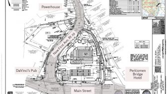
- Royal Farms land development and traffic plan (scalable pdf, 1.4mg).
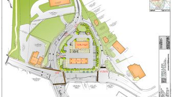
- Royal Farms land development and traffic plan, overall (scalable pdf, 2.7mg)
Plans and renderings courtesy Robert E. Blue, Consulting Engineers, P.C.
Rt 29 along the borough’s commercial corridor is referred to as Second Avenue and along the Perkiomen Creek, First Avenue. Under the new traffic plan, traffic on Second Avenue will no longer zig and zag through a dogleg, but enter First Avenue directly, and vice versa. The plan will also move the access to the Powerhouse to line up with the Royal Farms entrance resolving the line of sight issue at its current location.
Meanwhile, traffic entering the borough from the Perkiomen Bridge and wanting to access First Avenue will no longer turn at the light at the Perkiomen Bridge Hotel, but will proceed to the light at McDonald’s. And for traffic that turns left onto Second Avenue, the left turn queues will be lengthened. The combination of limiting turns at the hotel—which in turn limits the length and frequency of the light’s cycle—and lengthening the queues increases flow at this point.
The cut off portion of First Avenue will become one way, disallowing northbound movement. It will instead serve as an access road to businesses and homes located there. The light, however, will remain to provide access to the road, and to allow access to Kaiser & Miller Ford, especially for auto transport trucks which cannot use the Second Avenue entrance due to the slope.
After realignment the new First Avenue will be transferred to PennDOT, and they in turn will abandon the former, turning it over to the borough.
The Last Details
 The commissioners questioned the increase in the turning radius at the property’s main entrance that the developer had added to the final plan. This is the only one of the two entrances that allows a left turn on exit. Traffic engineer Matt Hammond said the change allows a wider turn for fuel delivery trucks.
In his comments on the Highway Occupancy Permit Plan, Borough Engineer Dave Leh pointed out that delivery trucks will have to wait for cars exiting the property to clear before they can make the turn. In that scenario they will back up traffic through the Main Street intersection.
As a contingency, the commissioners requested that the store restrict the hours of fuel delivery. Although the developer did not agree to this, they did agree to have the Borough and police monitor their fuel deliveries via complaints to the borough for a period of nine months after opening.
The Borough Solicitor asked whether a 75-foot mast arm that will be erected at the corner of the DaVinci’s Pub lot to support signage and traffic lights could be moved onto an island in the intersection, or whether they could use the shorter, less obtrusive 50 mast PennDOT prefers. Mr. Hammond answered that all contingencies had been explored and locating the mast within an island was deemed unsafe for traffic. The only other alternative was the mono tube, the large upside down U-shaped mast seen on major highways. Considering the length of the span of the street that would be even more obtrusive.
Waivers
PennDOT requires a line-of-sight easement on the property and restricted several trees from the plan that will block the sight lines along Rt 29. The Commission provided a waiver to replace three of the trees in the problem area with shorter shrubs. The Commission also provided a waiver that all driveways shall be provided with a stopping area within which the grade shall not exceed 4 percent.
Borough Council approved the final plan at the Wednesday, October 2nd meeting.

